Wednesday, June 27, 2012

Grand Marais, MI to The Soo

This series of pictures is actually two days beginning from Grand Marais, MI.  Overnight stop at Whitefish Pt. Harbor of Refuge, and then the next morning on to the Soo where all the action took place.

Grand Marais to Whitefish Point on 06/24, 44.9 NM
Early Morning Wx Out Of GM, MI
Whitefish Pt. Light - Fog is Lifting
Old Commercial Fishing Boat
Derilict - Whitefish Pt. Harbor of Refuge

More Modern Work Boat
Transient Dock Space - Whitefish Pt Harbor of Refuge

 Whitefish Pt. to Soo - 06/25 - 39.1 NM

Whitefish Bay Light House
Middle Marker Buoy
Major Turn Mark Upbound Whitefish Bay
Less Common Spar Buoy Marking Channel
Ship Loading Canadian Side
Hong Kong Ship - Note Survival Vessel Mechanism
Approaching Canadian Lock
The More Placid Friendly Looking Lock!
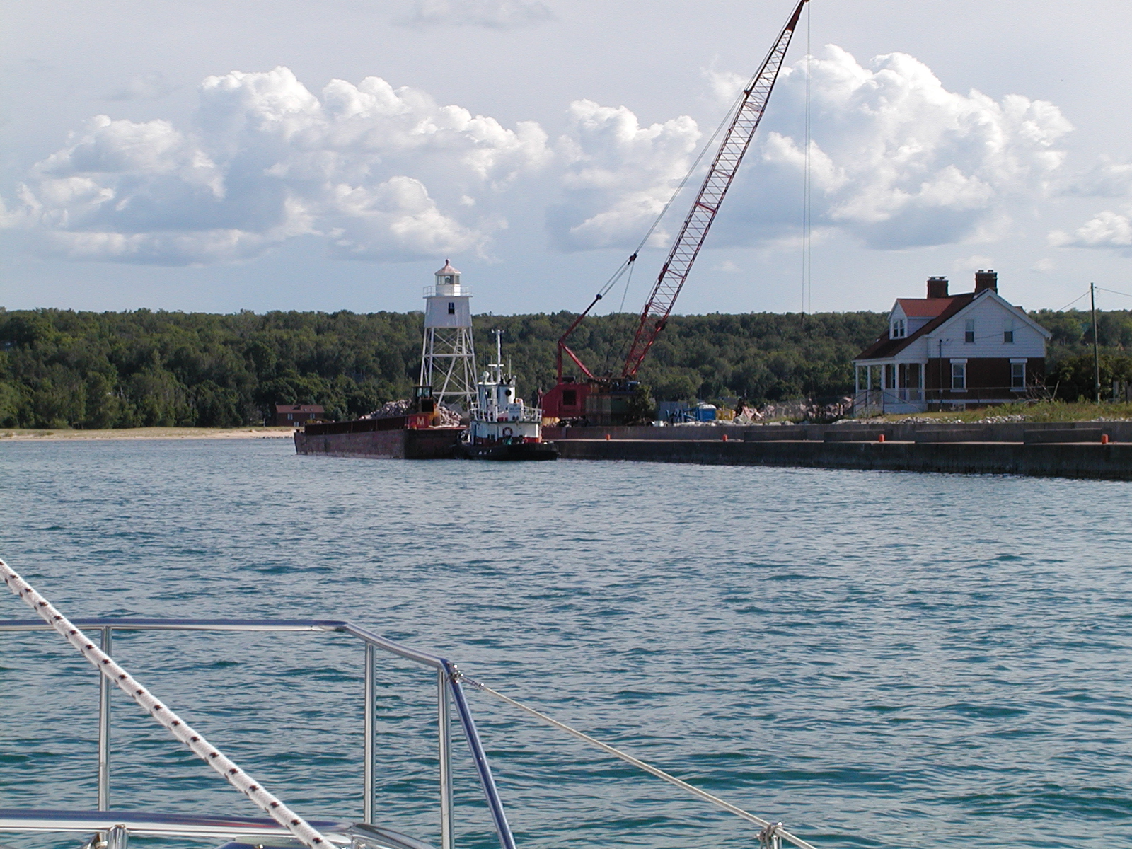
What I Got Stuck With!
NOTE:  Tug And Barge Jambed Firmly In Entry
More Peaceful Days - Ship Entering The Lock
Rested Three Days In The Soo
George Kemp Marina, USA Side Of Locks

Saturday, June 23, 2012

Grand Marais, Michigan

The trip from Caribou to Grand Marais, MI was routine and under power for the most part.  I sailed a little in the beginning but it did not last.  I was at anchor by 1800.  I turned over 5000 miles on my knot log coming into the harbor so I cleaned up and went to town for dinner to celebrate!

My primary purpose for coming to GM was to get gas but also to fill one propane bottle, if I could, and buy some groceries. 

I was previously thwarted in my effort to buy gas in Copper Harbor because the only station was closed in town and then the storm hit and I could not get off the boat for three hours.  I did not want to kill another day just waiting to get gas and I felt I would get plenty of wind going to Caribou.  However, the wind was not as forecast and using the engines cut too much into fuel reserves, thus requiring a stop in Grand Marais.

My original plan was to go direct White Fish Point Harbor of Refuge, but there are no facilities there and the Soo was around 100 NM.  My reserves were too thin and running out of gas going through the lock was not an option!  Thus I diverted to Grand Marais, MI.  Not a bad place to end up under the circumstances.

Approaching GM, Grand Sable Dunes just to west.
Tug with barge tied up at the wall.
The Tug "Duluth."
Working barge placing rock with small tug assisting.
My next boat, when I get out of sail...well maybe in another life!
The city has been waiting for this break wall for many years.  The previous one was destroyed in a large storm.
Sandy beach close by.  I waded right off the boat here last year, but too cool at 60 degrees this year!
Nice beach house.
My work boat for the day, hauling groceries, gas, propane, and garbage.
Mode Of Fuel Transportation
You can see the current harbor is open to NE.
Dash in the distance.
Interesting building.

City history.
Old ship anchor from an earlier time.
It's for sale!
The Pickle Barrel House
The history of the house.
The rain is coming!
Propane tank and groceries on the dolly.

Great for hauling longer distances, saves my back and arms!  I trucked gas on the dolly from the local station, six total today (30 gallons). 

The hardware store does propane, but only on a schedule, 4 pm each day,... only in small towns.  Kind of like shutting down the only gas station for four days!  The surprise was that I could get the tank filled at all.

The ship is loaded and ready to launch in the morning weather permitting.  See you in the next one.

Use of AIS


For those who do not use AIS, but may be interested, here is a short primer on it's use. Can't encourage a purchase enough, especially if you sail in busy ship areas

In this instance, I installed an inexpensive receiver with an antenna splitter. It is attached to my laptop via USB. I use an independent blue tooth GPS unit for positioning with the laptop.

Later I added a splitter and connected it to my C80 Plotter as well, so I now have AIS on both. This demo shows the C80 since my laptop Bluetooth receiver is on the fritz again.

Since 2007 AIS transmitters have been approved and one is on my list to buy at some point. Back in 2007 I was planning to transit Newport Harbor, Long Island Sound, the East River, and the Hudson, so I felt I needed the ability to avoid ships, particularly at night! This receiver only was easy to install.

NOTE: Don't forget to click on pictures to enlarge for more detailed viewing.

Dash is the boat shape the ship is the purple wedge shape

On the C80 by placing the cursor over the ship it indicates the speed of the ship, the closest point of approach (CPA), and the time to closest point of approach (TCPA).

By selecting "AIS List" with soft button at the bottom of the screen you get the list of ships currently in range.
Rng = Range in nautical miles (NM)
Brg = Bearing from the bow of Dash, in this instance, the Tregurtha is 37.7 degrees off the port, or left side.

The bearing is critical. If angle is increasing the ship will pass astern, if the angle is decreasing the ship will pass the bow, if bearing does not change you are on a collision course with the ship, and depending on the alarm distance set (normally 1 mile for me), the C80 will sound an alarm the image will enlarge be outlined in red and flash, to warn you of that fact.  See pictures below of what it looks like.

By selecting Paul R. Tregurtha you get the details of the ship, more than you want to know, but much of it useful.
CPA 1.844 NM
TCPA 21m 18s
COG = Course over the ground
SOG = Speed over the ground
I am uncomfortable with less than one NM clearance, you can speed up, slow down, or change course to make changes to the CPA that give more margin when desired.


Here is the Flinterstar information.
CPA 4.046 NM, TCPA 1h 15m 15s

Paul Tregurtha on the bow at 1.8 NM. Note, ship is not on the upbound track. The one the ship should be on is behind Dash. So in fog, don't think ships are necessarily on the correct track. They cut corners to save fuel!

Here is what it looks like from on deck

Flinterstar passing over 4 NM astern. He is closer to the track, but still a long ways off.

It is reassuring to see the actual distance and time to the closest point of approach because when you are on the bow of a ship, even at 3.8 NM it looks scary! This happened later this particular day. See below:  

The Ship Saginaw Approaching Upbound For Marquette

CPA 1.4 NM in 19 minutes!
NOTE: Destination is wrong, he came from the Soo

Here is what it looks like!  I am crossing in front and you can still see his starboard side, not a comfortable feeling.

In the end he passed as the computer said, no closer than 1.4 NM but it made me nervous going in front of him and watching him bear down on me in my little boat!

Here is display after I cleared the shipping lane and he reaches the CPA.

The View At CPA - 1.4 NM
Here is an example of the what it looks like when you receive a warning.  The image is larger, outlined in red, and flashes. 


This is the target at about .5 NM, a tug pushing a barge upbound on Whitefish Bay.
Hope this has been helpful to any potential AIS users on the fence. 

___________________________________________________

Below is a little side note of interest regarding my Autotether System.


SIDE NOTE:
This is the Autotether engine shut down unit I installed. Both engines shut down if I fall overboard.
A small remote unit is inserted into my life vest. When the signal is disrupted by me being in the water, or too far away, the engines shut down. I plan to hook this to the autopilot as well, but it remains on the "to do" list.
Essential to this system is a means of getting back aboard when alone, so I installed an additional boarding ladder that can be deployed from the water by simply pulling it down.